All Glossary Terms
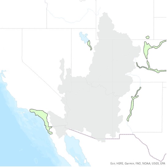
Short for adjacent areas served by Colorado River water. It refers to locales outside the hydrologic basin of the Colorado River, where its waters are exported via transbasin diversions. Most of the population that relies on Colorado River water lives in large cities in the Adjacent Areas Served, such as Denver, Los Angeles, and San Diego.
The Adjacent Areas Served, as defined in this report, generally correspond with the “adjacent areas that receive Colorado River water” as defined by the U.S. Bureau of Reclamation (2012), with two notable differences. One is the watershed of the Salton Sea, a portion of which is classified as an adjacent area by the Bureau of Reclamation because it receives Colorado River water via the All-American Canal and Colorado River Aqueduct but no longer contributes tributary flow to the river. However, before Hoover Dam was built, the Colorado River would sometimes migrate from its current channel and into the Salton Sink (see, e.g., Ross 2020). Because of that connection, we include it within the hydrologic CRB area, rather than in Adjacent Areas Served. See U.S. Bureau of Reclamation, 2012, p. ES-3.
The second exception is the area in northwestern Mexico encompassing the cities of Tijuana and Ensenada. Colorado River water is exported to Tijuana via the Colorado River-Tijuana aqueduct. For our purposes this counts as an AAS, but since it is a Mexican infrastructure project, it is not included in Bureau of Reclamation service area maps. The city of Ensenada is included in this area because Tijuana sends Colorado River water there via a pipeline that was originally constructed to pump water in the opposite direction. Although in our map this area may appear contiguous with the Southern California AAS that includes San Diego and Los Angeles, it is not part of the same service area on account of the international border.
The SWP is a state water management project in California under the supervision of the California Department of Water Resources. It is one of the largest public water and power utilities in the world, providing drinking water for more than 23 million people and generating an average of 6,500 GWh of hydroelectricity. Sources: California State Water Project – Wikipedia; State Water Project (ca.gov).
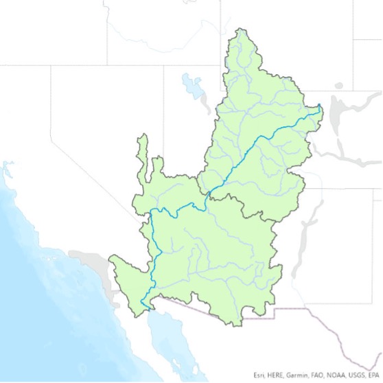
The area drained by the Colorado River and its tributaries; a hydrologic boundary including the combined areas of the Upper Colorado and the Lower Colorado Basins. When we use the term Colorado River Basin in this study, we refer to an area that differs slightly from the HUC-02 Region shapefiles in the USGS National Hydrography Dataset (see entry for Hydrologic Unit Code). We exclude some watersheds whose tributaries do not flow directly into the Colorado River, including the Great Divide Closed Basin (HUC ID: 140402) and several basins along the Arizona-Mexico border that flow directly into the Sea of Cortez (e.g., Río Sonoita and Río Concepción). We also include a few areas that are not in the HUC-02 Region footprints of the Upper or Lower Colorado within the National Hydrography Dataset, most notably the areas around the Salton Sea and Laguna Salada in Mexico. The Colorado River, like all rivers, shifts over time. Before Hoover Dam closed, the Lower Colorado would migrate wildly and often swung westward to feed directly into the Salton Basin, hence we include that area as part of the Colorado River Basin rather than within the Adjacent Areas Served. For more, explore the Babbitt Center’s map of the Colorado River Basin.
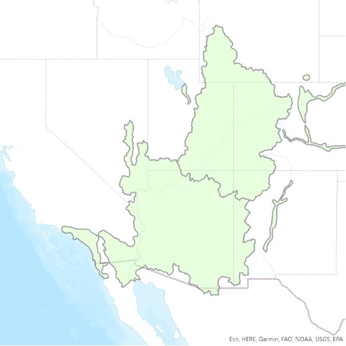
This is the combined area of the hydrologic Colorado River Basin boundary (see CRB definition for exceptions) and the Adjacent Areas Served via transbasin diversions (see AAS definition). The CRBAAS had an estimated population of 43 million people in 2021.
A water utility that supplies water to the same population year-round. It serves at least 25 people at their primary residences or at least 15 residences that are primary residences. Over 286 million Americans get their tap water from a community water system. Sources: Public Water Systems | Drinking Water | Healthy Water | CDC; Factoids: Drinking Water and Ground Water Statistics for 2007, March 2008 (epa.gov).
When water is removed from available supplies without return to a water resource system. In the case of irrigation, consumptive use is the amount of water that does not flow off the field and returns to the canal or water body for re-use. Source: Consumptive water use – Wikipedia.
The water used to make a product. For example, dry cereal contains all the water used to grow, clean, and process its grain, plus the water used to produce the cardboard box it comes in. Source: Virtual water – Wikipedia.
Often shortened to just “Front Range” this refers to an oblong region with a population of more than five million, located along the eastern face of the Southern Rocky Mountains. It encompasses 18 counties in Colorado and Wyoming and is named after the mountain range that defines the corridor’s western boundary. Source: Front Range urban corridor – Wikipedia.
A way to measure how much water each person in a community uses each day. This is typically calculated in aggregate for communities, counties, or states, or nationally, by dividing the total volume of water used in a month, divided by the total population and the number of days in that month. Major discrepancies exist in how different entities calculate GPCD, which population numbers they use, and the source of those numbers (full-time resident, transient, census, state demographers), making it difficult to compare numbers across state lines or across communities. The indicators report uses GPCD numbers from the USGS National Water Use Science Project, part of the National Water Census.
A summary measure that provides information on the state of, or change in, the system being measured. Sometimes used interchangeably with metric, as in this report. See also Metric. Source: Fiksel et al. (2012).
The measured value(s) used to assess specific indicators. It defines the units and how the indicator is being measured. Sometimes used interchangeably with indicator. Source: Fiksel et al., 2012.
A regional wholesaler and the largest supplier of treated water in the United States. The name is usually shortened to “Met,” “Metropolitan,” or “MWD.” It is a cooperative of fourteen cities, eleven municipal water districts, and one county water authority, that provides water to 19 million people in a 5,200-square-mile (13,000 km2) service area. It was created by an act of the California State Legislature in 1928, primarily to build and operate the Colorado River Aqueduct. Metropolitan became the first (and largest) contractor to the State Water Project in 1960. Source: Metropolitan Water District of Southern California – Wikipedia.
A classification of housing where multiple separate housing units for residential inhabitants are contained within one building or several buildings within one complex. Units can be next to each other (side-by-side units) or stacked on top of each other (top and bottom units). A common form is an apartment building. Many intentional communities incorporate multifamily residences, such as in cohousing projects. Sometimes units in a multifamily residential building are condominiums, where typically the units are owned individually rather than leased from a single apartment building owner. Source: Multifamily residential – Wikipedia.
The NLCD includes spatial reference and descriptive data for the land surface, such as thematic class (for example, urban, agriculture, and forest), percent impervious surface, and percent tree canopy cover. The database provides cyclical updates of United States land cover and associated changes. Systematically aligned over time, the database makes it possible to understand both current and historical land cover and land cover change and enables monitoring and trend assessments. Sources: The National Land Cover Database Factsheet; Land Cover | Multi-Resolution Land Characteristics (MRLC) Consortium.
The average amount of water each person in a particular area uses daily, often expressed in gallons per capita per day, or GPCD. See also GPCD.
These describe potential scenarios for societal change through 2100. Using complex Integrated Assessment Models, SSPs anticipate how possible changes in population, energy use, and technology, among other things, could influence—and be influenced by—climate change.
The Scenarios are:
SSP1: Sustainability (taking the green road) RCP 1.9-2.6
1 – 2.4ºC degrees of warming by 2100
SSP2: Middle of the road scenario RCP 4.5 (most likely)
2.1 – 3.5ºC degrees warming by 2100
SSP3: Regional Rivalry (a rocky road) RCP 7.0
2.1 -3.5ºC degrees warming by 2100
SSP4: Inequality (a road divided)
(RCP and degrees warming not provided in IPCC6)
SSP5: Fossil-fueled Development (taking the highway) RCP 9.5
3.3 – 5.7 degrees of warming by 2100
Source: Shared Socioeconomic Pathways – Wikipedia.
Transbasin diversions, also called interbasin transfers, are man-made conveyance schemes which move water from one river basin where it is available, to another basin where water is less available or could be utilized better for human development. Source: Interbasin transfer – Wikipedia.