All Glossary Terms
“Show me the water” requirements (comprehensive plans)
Also known as adequate or assured water supply rules, this topic can be addressed in a community’s comprehensive plan, in the category of water-efficient land use. It involves demonstrating adequate water supply before approving new development, creating new subdivisions, changing zoning, or redeveloping areas with different land use. Source: Rugland, 2020.
(A)
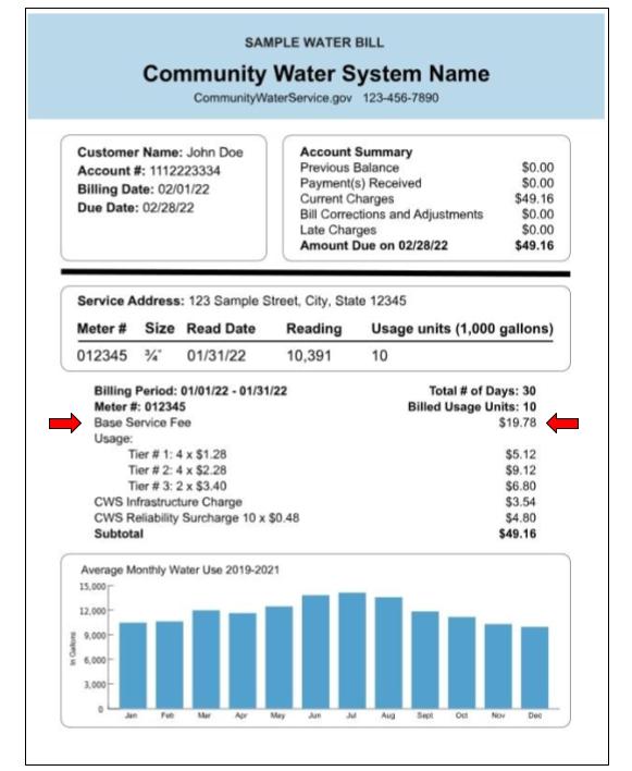
Base fee for service
(B)
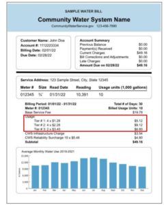
Rate structure (tiers) and monthly usage
(C)
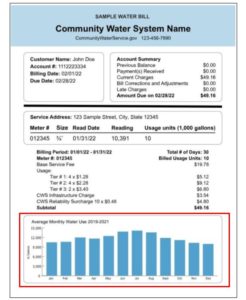
Past usage graphed.
(D)
Additional fees or charges, often associated with infrasturucture improvements.

(E)
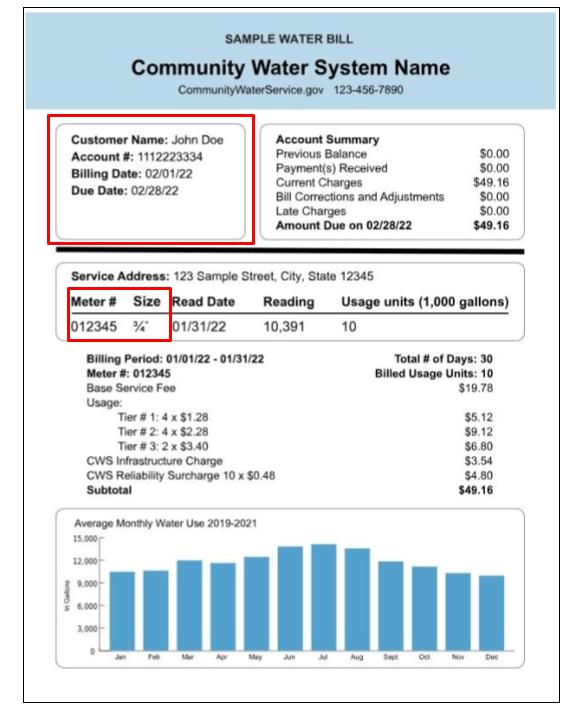
Information about your account type and meter
(F)
Dates of service and summary of charges

Accessory dwelling units (ADUs) (or secondary suites)
Self-contained apartments, cottages, or small residential units, that are located on a property that has a separate main, single-family home, duplex, or other residential units. Source: Secondary suite - Wikipedia.
Acre-foot
Non-SI unit of volume equal to about 1,233 cubic meters of water or 325,850 gallons. As the name suggests, an acre-foot is defined as the volume of one acre of surface area to a depth of one foot. Source: Acre-foot - Wikipedia.

Active Management Area (AMA)
In Arizona, an area that relies heavily on mined groundwater and is regulated by the 1980 Arizona Groundwater Code. Arizona has five AMAs, each named for its largest city or county: Prescott, Phoenix, Pinal, Tucson, and Santa Cruz. Source: Active Management Area Overview | Arizona Department of Water Resources (azwater.gov).
Adjacent Areas Served (AAS)
Short for adjacent areas served by Colorado River water. It refers to locales outside the hydrologic basin of the Colorado River, where its waters are exported via transbasin diversions. Most of the population that relies on Colorado River water lives in large cities in the Adjacent Areas Served, such as Denver, Los Angeles, and San Diego. The Adjacent Areas Served, as defined in this report, generally correspond with the “adjacent areas that receive Colorado River water” as defined by the U.S. Bureau of Reclamation (2012), with two notable differences. One is the watershed of the Salton Sea, a portion of which is classified as an adjacent area by the Bureau of Reclamation because it receives Colorado River water via the All-American Canal and Colorado River Aqueduct but no longer contributes tributary flow to the river. However, before Hoover Dam was built, the Colorado River would sometimes migrate from its current channel and into the Salton Sink (see, e.g., Ross 2020). Because of that connection, we include it within the hydrologic CRB area, rather than in Adjacent Areas Served. See U.S. Bureau of Reclamation, 2012, p. ES-3. The second exception is the area in northwestern Mexico encompassing the cities of Tijuana and Ensenada. Colorado River water is exported to Tijuana via the Colorado River-Tijuana aqueduct. For our purposes this counts as an AAS, but since it is a Mexican infrastructure project, it is not included in Bureau of Reclamation service area maps. The city of Ensenada is included in this area because Tijuana sends Colorado River water there via a pipeline that was originally constructed to pump water in the opposite direction. Although in our map this area may appear contiguous with the Southern California AAS that includes San Diego and Los Angeles, it is not part of the same service area on account of the international border.
Anthropogenic warming (or anthropogenic climate change)
Combines the terms climate change and anthropogenic. Anthropogenic climate change refers to warming of the planet that can be attributed to human activities. Source: IPCC, 2018. See also Climate change.
Average water consumption (or average winter consumption) (AWC)
A concept used in water budget–based rates to define tiers or blocks. It is usually calculated by estimating the average annual amount of water used by a household based on past water bills and household characteristics, or the average over the course of the winter, which typically excludes outdoor use. Those totals can determine how much water is required for basic needs and how much water use is excessive or wasteful. Generally, water budget–based rates are higher for consumption that exceeds AWC than for water use that is less than or equal to AWC. See Understanding Your Water Bill | US EPA.
Base service fee
What a community water system charges, regardless of water use. It is meant to recover costs of utility overhead such as reading and maintaining meters, carrying out billing, or other expenses. All water users incur this fee, although prices may vary by account type, meter size, location, zoning type, or use. Sometimes, base service fees include a built-in amount of usage (e.g., the base service fee might include 5,000 gallons of water before additional usage charges are incurred). Source: Understanding Your Water Bill | US EPA.
Beneficial use
The Cornell Law School Legal Information Institute states: "Beneficial use is a term most commonly associated with water rights in the western United States and the prior appropriation doctrine. Many state statues describe beneficial use as the basis, measure, and limit of a water right. Because these states define water sources as public resources, non-riparian land owners can acquire a right to the use of a water source when they put its water toward beneficial use. However, the extent of their right is limited by the beneficial use..." Source: beneficial use | Wex | US Law | LII / Legal Information Institute (cornell.edu).
Building and plumbing policies (comprehensive plans)
These are part of a community’s comprehensive plan, in the category of water-efficient land use, which deals with provisions to update plumbing in new, existing, or retrofitted buildings or homes. Such measures can help reduce indoor water use and may be implemented through incentives such as rebates, regulations, or guidelines. Source: Rugland, 2020.
California State Water Project (SWP)
The SWP is a state water management project in California under the supervision of the California Department of Water Resources. It is one of the largest public water and power utilities in the world, providing drinking water for more than 23 million people and generating an average of 6,500 GWh of hydroelectricity. Sources: California State Water Project - Wikipedia; State Water Project (ca.gov).
Centum Cubic Feet (CCF)
A volumetric unit community water systems apply to meter water use. One CCF is equivalent to about 748 gallons of water and is used interchangeably with hundred cubic feet (HCF). Centum comes from the Roman word for hundred. See also HCF.
Climate Change
Refers to a shift in climate that can be identified by shifts in the mean and/or the variability of its properties (temperature, precipitation, etc.) and that typically persists for decades or longer. Climate change may be caused by natural internal processes--such as volcanic eruptions, plate tectonics; by external forces--such as modulations of the solar cycles, or by persistent anthropogenic changes in the composition of the atmosphere or in land use. Source: IPCC, 2018.
Climate models
Also known as general circulation models (GCMs), these use mathematical equations to determine how energy and matter interact in different parts of the ocean, atmosphere, and land. Based on well-documented physical processes, they simulate the transfer of energy and materials through the climate system. Source: Climate Models | NOAA Climate.gov.
Collaboration for land and water (comprehensive plans)
In a community’s comprehensive plan, this can fall under the category of water-efficient land use, to describe the collaboration between land and water management entities in local government. This may include aligning agencies’ data, continuous research and monitoring, collaborating on development codes, holding regular meetings between planning and water departments, coordinating among jurisdictions and across watersheds or basins, participating in watershed or basin-wide groups. Source: Rugland, 2020.
Colorado River Basin (CRB)
The area drained by the Colorado River and its tributaries; a hydrologic boundary including the combined areas of the Upper Colorado and the Lower Colorado Basins. When we use the term Colorado River Basin in this study, we refer to an area that differs slightly from the HUC-02 Region shapefiles in the USGS National Hydrography Dataset (see entry for Hydrologic Unit Code). We exclude some watersheds whose tributaries do not flow directly into the Colorado River, including the Great Divide Closed Basin (HUC ID: 140402) and several basins along the Arizona-Mexico border that flow directly into the Sea of Cortez (e.g., Río Sonoita and Río Concepción). We also include a few areas that are not in the HUC-02 Region footprints of the Upper or Lower Colorado within the National Hydrography Dataset, most notably the areas around the Salton Sea and Laguna Salada in Mexico. The Colorado River, like all rivers, shifts over time. Before Hoover Dam closed, the Lower Colorado would migrate wildly and often swung westward to feed directly into the Salton Basin, hence we include that area as part of the Colorado River Basin rather than within the Adjacent Areas Served. For more, explore the Babbitt Center’s map of the Colorado River Basin.
Colorado River Basin and Adjacent Areas Served (CRBAAS)
This is the combined area of the hydrologic Colorado River Basin boundary (see CRB definition for exceptions) and the Adjacent Areas Served via transbasin diversions (see AAS definition). The CRBAAS had an estimated population of 43 million people in 2021.
Colorado River Compact of 1922
An agreement among the seven Southwest U.S. states that fall within the Colorado River drainage basin. The pact governs the allocation of the river’s water rights. Originally proposed by attorney Delph Carpenter, the agreement was signed at a meeting at Bishop’s Lodge, near Santa Fe, by representatives of the seven states the Colorado River and its tributaries pass through on the way to Mexico. Arizona did not formally ratify the compact until 1944. Sources: Colorado River Compact - Wikipedia; Danver, 2013.
Colorado River naturalized flow at Lees Ferry, AZ
An estimate of the annual streamflow volume of the Colorado River if it were unimpaired by dams, diversions, and withdrawals. This is calculated annually for each water year (October–September) by the Bureau of Reclamation and the Upper Colorado River Commission using data from upstream gauges, diversions, and consumptive use, and comparing that to historical data. It is calculated at Lees Ferry, AZ, which is the dividing line between the Upper and Lower Colorado River Basins. Source: Naturalized Flow of the Colorado River USBOR.
Community resilience (National Risk Index)
The ability of a community “to prepare for anticipated natural hazards, adapt to changing conditions, and withstand and recover rapidly from disruptions (NIST, 2020).” As a consequence-reduction risk component of the National Risk Index, a community resilience score and rating represent a community’s resilience compared to that of all other communities at the same administrative level (e.g., county, census tract). A community resilience score is inversely proportional to a community’s risk. A higher community resilience score results in a lower Risk Index score. Source: FEMA, 2023.
Community water system (CWS)
A water utility that supplies water to the same population year-round. It serves at least 25 people at their primary residences or at least 15 residences that are primary residences. Over 286 million Americans get their tap water from a community water system. Sources: Public Water Systems | Drinking Water | Healthy Water | CDC; Factoids: Drinking Water and Ground Water Statistics for 2007, March 2008 (epa.gov).
Composite risk score (National Risk Index)
Measures the relative risk to a community based on 18 natural hazards. Source: Determining Risk | National Risk Index (fema.gov). See also: National Risk Index.
Comprehensive plan
Also known as a general plan or master plan, this lays out a community’s goals and aspirations for its development, covering a broad range of topics and a years-long time horizon. Such plans are adopted and updated by cities, towns, counties, or other communities to determine priorities and public policies on transportation, land use, recreation, and housing. Sources: Rugland, 2020; Kelly, 2009.
Consumptive water use
When water is removed from available supplies without return to a water resource system. In the case of irrigation, consumptive use is the amount of water that does not flow off the field and returns to the canal or water body for re-use. Source: Consumptive water use - Wikipedia.