The Hardest-Working River in the West: Colorado River Streamflow
Examining the annual naturalized streamflow of the Colorado River
The Colorado River has been called “The Hardest-Working River in the West,” a reputation that is well earned. On its 1,450-mile1 journey from the Rocky Mountains to the Gulf of California, its waters are dammed, diverted, used, and reused countless times, supporting ecosystems and human needs in two countries, seven US states, two Mexican states, and 30 tribal communities in the region. Its waters partially support the needs of several major western cities including Los Angeles, San Diego, Phoenix, Denver, and Las Vegas. Regionally, at least $1.4 trillion in economic activity and 16 million jobs rely partly on the Colorado (James, Madly, and Kelly 2014 Citation).
In 1922 the Colorado River Compact Definition2 was signed, forming the cornerstone of the Law of the River Definition3, a collection of laws, decrees, memorandums, and precedents that determine the allocation of water among the seven US Basin states, 30 tribes, and Mexico (Danver 2013 Citation). The river’s waters are overallocated primarily due to inaccurate assumptions about the river’s average annual flow volume. In 1922, when the compact was negotiated, the Colorado’s average annual flow volume was estimated at 16.4 million acre-feet Definition(MAF). That was based on hydrologic data from 1905 to 1922, which is now recognized as an unusually wet period in the Colorado River Basin. The long-term annual average is now estimated at closer to 14.6 MAF, and many years have lower flows.
The system of reservoirs in the Basin was built for a variety of reasons: to regulate transfers of water between the Upper and Lower Basins; to generate power; to create revenue to offset other projects; to control floods; and to store water from wet years to meet Compact obligations in dry years (U.S. Bureau of Reclamation 1950 Citation). The Colorado River’s reservoirs can store over four times its annual average flow volume, but the persistent drought has left the nation’s two largest reservoirs, Lakes Mead and Powell, at about 31% and 39% capacity, respectively, as of June 2023. 4
Aside from its overallocation, perhaps the biggest challenge facing the Colorado River in future decades is a warming climate. Anthropogenic (human-caused) warming Definition has altered snowpack and snowmelt timing, increased the precipitation that falls as rain rather than snow, caused drier soils and stressful conditions for plants, and increased the size and frequency of wildfires (Iglesias, Balch, and Travis 2022 Citation; Milly and Dunne 2020 Citation; Solander et al. 2018 Citation; Clow 2010 Citation). Higher average temperatures have led to more frequent and stronger “extreme events” (weather events that are unusual in the historical record), leading to more heatwaves and flooding, and increasing the probability of prolonged droughts and reduced streamflow Definition (Bennett, Talsma, and Boero 2021 Citation).
Data from weather stations and stream gauges combined with reconstructions of past climate using tree rings and other proxy data indicate that 2000–2021 was the driest 22-year period since 800 CE (Williams, Cook, and Smerdon 2022 Citation). The twenty-first-century’s Millennium Drought, or southwest North American mega-drought Definition, as it’s been variously called, has continued through 2022 and led to significant reductions in streamflow—16.5% less in the Upper Colorado River from 1916 to 2014 (Xiao, Udall, and Lettenmaier 2018 Citation).
Indicator 1 : Annual Naturalized Streamflow of the Colorado River
9.8 Million Acre-Feet (2022)
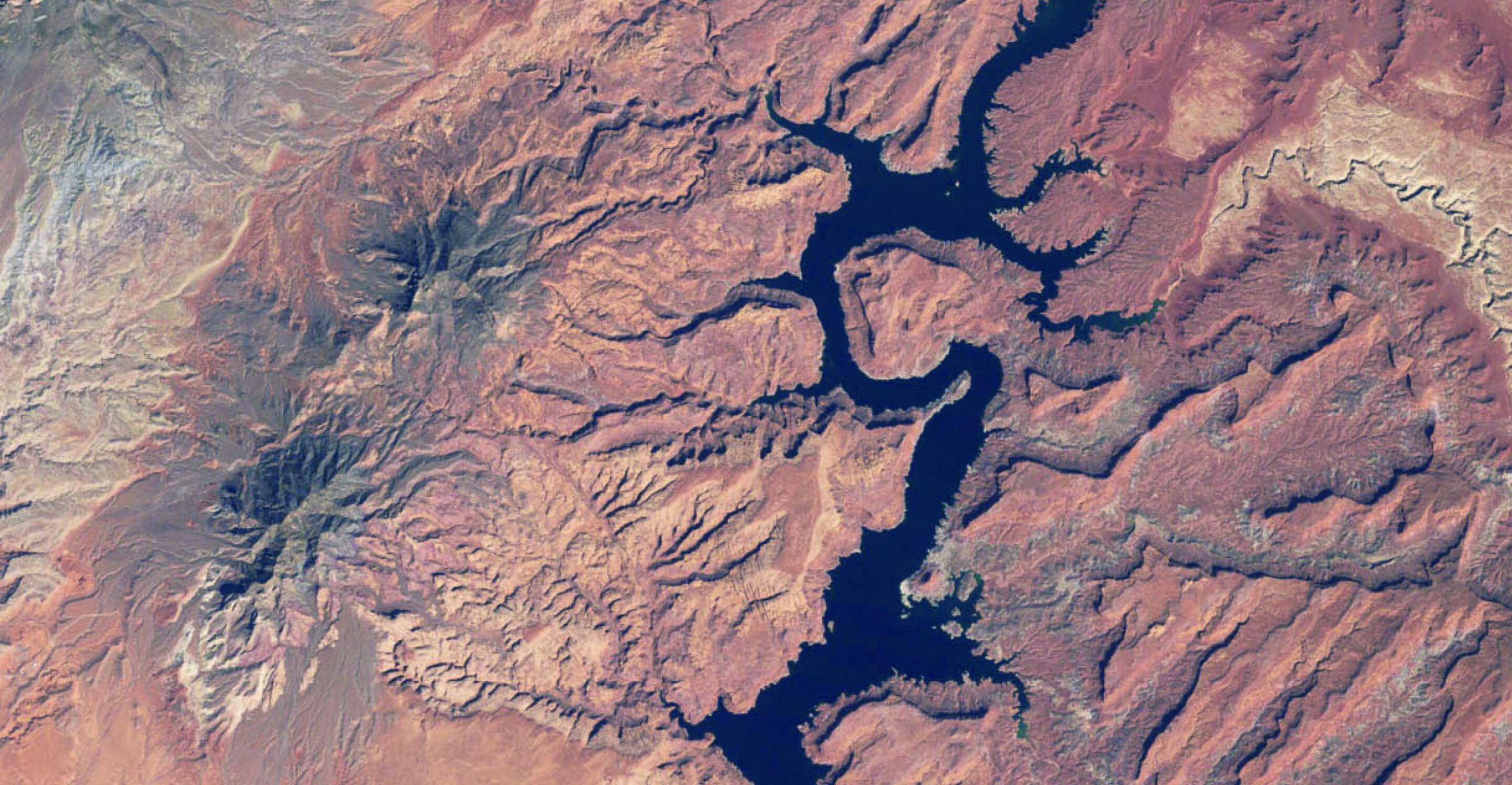
This leads us to our first indicator: the naturalized streamflow of the Colorado River at Lees Ferry. We view naturalized streamflow as a synthesis indicator capturing the effects of climate and land use on a water supply that tracks the evolution of the Millennium Drought. Lees Ferry5 is a commonly used boundary demarcating the Upper and Lower Colorado River Basin for water accounting purposes, with long-term records of streamflow from gauges and tree ring reconstructions (Williams, Cook, and Smerdon 2022 Citation; Woodhouse, Gray, and Meko 2006 Citation).
Naturalized flow is an estimate of the total annual flow volume of Colorado River water that would pass by Lees Ferry, Arizona Definition, in the absence of dams or diversions. This estimate gives water managers and stakeholders insights into how much Colorado River water is available in any given year and allows us to compare our current water year Definition to the river’s historical records of flow.
Preliminary estimates of naturalized flow in 20226 are about 9.8 million acre-feet (MAF), or 67% of its average annual flow volume from 1906 to 2021 (14.6 MAF). Official data for the average annual flow over the decade from 2012 to 2021 was 11.7 MAF, or 84% of the long-term average. The winter of 2023 was historically wet for much of the southwest; the naturalized flow volume for 2023 was an estimated 18.5 (MAF) which is above average but not yet enough to signal the end of the Millennium Drought.
Streamflow in the Colorado has declined by about 20% over the last century, and about half of that decline has been attributed to climate change (Hoerling et al. 2019 Citation). One recent study found that in the presence of continued anthropogenic warming, in 75% of simulations of future temperature and precipitation, it is estimated that the current drought will continue until at least 2028 (Williams, Cook, and Smerdon 2022 Citation).
Climate models Definition widely predict that warming will continue in the Colorado River Basin, resulting in an average increase of 5.5º C by the end of the century (Bennett, Talsma, and Boero 2021 Citation).7 Even if precipitation increases, which is highly uncertain according to climate models, warming will continue to strain water resources and likely reduce Colorado River streamflow (Milly and Dunne 2020 Citation; Overpeck and Udall 2020 Citation; Udall and Overpeck 2017 Citation). As temperatures rise, the difference between moisture in the air and the amount of moisture that air can hold, known as vapor pressure deficit, increases the amount of water drawn from plants and soils through evaporation and transpiration (or evapotranspiration [ET] Definition). In future models, increases in precipitation due to warming will likely be insufficient to balance out higher ET rates associated with warming temperatures and vapor pressure deficits (Zhou et al. 2019 Citation; Udall and Overpeck 2017 Citation).
With over two decades of drought and below-average streamflow, and with climate models predicting an increased likelihood of drought and streamflow reductions, communities must look for indicators of land and water to better plan for the future. Specifically, they should consider water supply and demand. Regional changes in population and demographics will shape future demand but so will municipal planning and the forms of development that take place. Land use conversions and loss of forest, along with increases in developed areas, will influence water supply and quality. The price of water can send important signals to customers, incentivizing conservation or perpetuating wasteful or unnecessary use. The indicators provided in the following chapters are not comprehensive but do provide a springboard to delve deeper into the land and water trends that will affect the Basin’s water future.